Earlier this week, the Augmented Traffic team released version 1.0.3 of their Augmented Traffic Views app for the Android system. This app is the latest in the wave of augmented reality apps, apps which overlay the android camera and blur the line between the real world and the virtual world.
The Augmented Traffic app is available in approximately 25 metro locations, and uses the city’s traffic cameras to provide real-time traffic information for commuters. For the last few days I have been testing this application on my daily commute.
I have been very impressed with the speed at which the app picks up your location. The location feature has the same level of accuracy we have come to expect with Google maps, and manages to pick up your location in about 5 seconds. Very quick compared to some of the other GPS apps out there.
The app has two main features: Auto Tracking and Augmented Views. The auto tracking feature starts with your location, determines which direction you’re traveling, and cycles through the next 5-7 traffic cameras. This gives the user an idea of whether or not they should be trying to find and alternate route, which is often a necessity while traveling through hectic downtown Minneapolis.
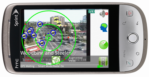
The augmented views feature uses your phone’s camera to display green dots which represent all traffic cameras in the area. A quick tap of one of the green dots gives the user the real time camera view of the location. It additionally uses the traffic cameras to roughly calculate which lane on the highway will provide the quickest route for the user.
The goal that the Augmented Traffic team is trying to accomplish is a very righteous one. People want real-time traffic information presented in such a way that they can utilize the information to make better commuting decisions. That being said, I can’t really see myself using this app on a daily basis. When it comes to real-time traffic information (which generally requires the user to be driving to make any use of the information), simpler is better. One quick look at Google maps provides a color-coded traffic system that individuals can make snap route decisions and put the phone down and drive. The augmented reality feature, while very cool to try, simply does not have the everyday application that a Google Maps or a CoPilot Live offers.